Herunterladen Inhalt Inhalt Diese Seite drucken

Werbung

Verfügbare Sprachen

Verfügbare Sprachen

DE | EN
FGS 1
BEDIENUNGSANLEITUNG
USER MANUAL
www.geo-fennel.de
www.geo-fennel.com
www.geo-fennel.fr

Werbung

Inhaltsverzeichnis
loading

Inhaltszusammenfassung für geo-FENNEL FGS 1

  • Seite 1 DE | EN FGS 1 BEDIENUNGSANLEITUNG USER MANUAL www.geo-fennel.de www.geo-fennel.com www.geo-fennel.fr...
  • Seite 2 5. Bedienung 6. Sicherheitshinweise LIEFERUMFANG – FGS 1 Komplett-SET • 2 x GNSS-Antennen FGS 1 • 4 x Li-Ion-Batterien für FGS 1 • 2 x Ladestation • 2 x Verbindungskabel USB • 2 x Verbindungskabel RS232 • 1 x Adapterstab für Dreifußadapter •...
  • Seite 3 • 1 x USB-Verbindungskabel für Handempfänger • Softwarepaket • Bedienungsanleitung • Koffer LIEFERUMFANG – FGS 1 Antenne • 1 x GNSS-Antenne FGS 1 • 2 x Li-Ion-Batterie für FGS 1 • 1x Ladestation • 1x Verbindungskabel USB • 1x Verbindungskabel RS232 • Softwarepaket • Bedienungsanleitung •...
  • Seite 4: Batterie Einlegen

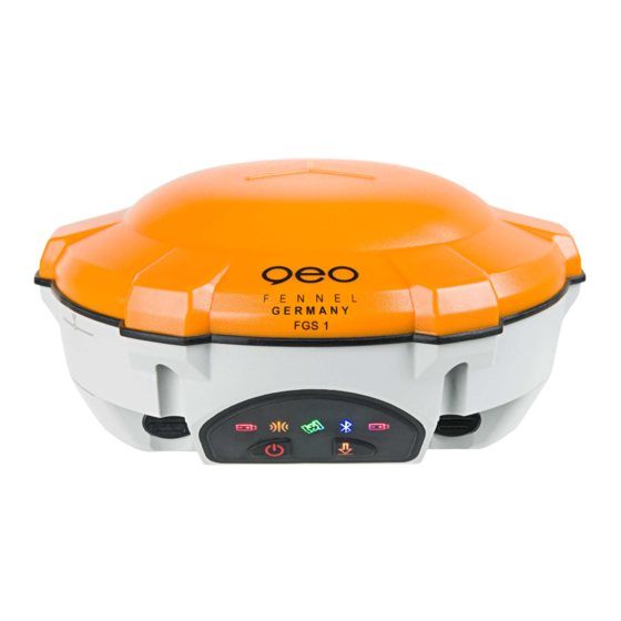
    BEDIENFELD Anzeige Status Bedeutung Differential-LED Blinkt einmal pro Sekunde empfängt/sendet Daten Satelliten-LED keine Anzeige oder einmal alle Satelliten werden gesucht 5 Sekunden Blinkt N-mal alle 5 Sekunden N Satellitensignale werden empfangen Bluetooth®-LED Blinkt Gerät ist verbunden Batterie-LED Leuchtet Batterie ist geladen Blinkt Batterie ist schwach Data-Logging-LED...
  • Seite 5: Bedienung

    BEDIENUNG Die Basisantenne über einem bekannten oder anonymen Punkt aufstellen und einschalten. Die Rover- Antenne wird auf einen Antennenstab geschraubt und eingeschaltet. Halteklammer auf bequemer Ar- beitshöhe befestigen. Der Handempfänger wird in die Halterung eingelegt und über die Klemmschraube fixiert. Starten Sie das Programm FieldGenius auf dem Feldrechner. Erste Schritte Nach dem ersten Start der Software öffnet sich automatisch die Registrierungsaufforderung.
  • Seite 6 Nachdem die Einstellungen durchgeführt worden sind bestätigen Sie das neue Projekt mit OK. Im nächs- ten Schritt richten Sie die GPS-Antenne ein. Es können sowohl die Basisstation eingerichtet als auch der Rover via Bluetooth oder serieller Kabelverbindung an die Software angebunden werden. Nach der An- bindung gelangen Sie automatisch in das Hauptmenü.
  • Seite 7 Hauptmenü: durch Drücken springt die Anzeige in das Hauptmenü. Minimiert die Anzeige. Schaltet „Linien zeichnen“ an/aus. Schaltet „Kurven zeichnen“ an/aus. Schaltet „3-Punkt-Bogen-zeichnen“ an/aus. Diesem Knopf kann eine Funktion frei hinzugefügt werden. Zeigt die Nummer des nächsten Punktes an. Ähnlich der „Linien zeichnen“-Funktion: aus einer Liste können Punkte gewählt werden die mit einer Linie verbunden werden können.
  • Seite 8: Warn- Und Sicherheitshinweise

    Nach Beendigung der kompletten Aufnahme der Punkte verbinden Sie die Antenne mit der mitgelieferten Konfigurationssoftware, um die einzelnen Dateien aus der Antenne auszulesen. Zusätzlich ermöglicht es Ihnen die Software, die Antennenhöhe und den Dateinamen vor dem Download zu verändern. Über die geo-FENNEL-Postprocessing-Software können die einzelnen Datenpakete geöffnet und ausge- wertet werden. SICHERHEITSHINWEISE WARN- UND SICHERHEITSHINWEISE •...
  • Seite 9: Garantie

    CE-KONFORMITÄT Das Gerät hat das CE-Zeichen gemäß den Normen EN 60950-1:2006+A11:2009 +A1:2010+A12:2011+A2:2013; EN 62479:2010; ETSI EN 301 489-1 V1.9.2 ETSI EN 301 489-3 V1.6.1 EN 55022: 2010 EN 55024: 2010; ETSI EN 300 440-1 V1.6.1 ETSI EN 300 440-2 V1.4.1 GARANTIE Die Garantiezeit beträgt zwei (2) Jahre, beginnend mit dem Verkaufsdatum.
  • Seite 10 Dear Customer, Thank you for your confidence in us, having purchased a geo-FENNEL instrument. For the optimum performance of the instrument, please read this manual carefully and keep it in a con- venient place for future reference. This manual contains important safety information that should be read and understood before use.
  • Seite 11 • 1 x USB-Connection Cable for Fieldcontroller • Software • User Manual • Case SUPPLIED WITH – FGS 1 Antenna single receiver (Base) configuration • 1 x GNSS-Antenna FGS 1 • 2 x Li-ion-Batteries for FGS 1 • 1x Charging Station •...
  • Seite 12: Insert Battery

    KEYPAD LAYOUT Anzeige Status Bedeutung Differential LED Flashs once per second receiving/transmitting differential data Satellite LED Extinguishing or flashing once Searching satellites per 5 seconds Flashs N times per 5 seconds Receiving N satellites Bluetooth® LED Flashing Other devices connected to the anten- Battery LED Illuminated Enough power...
  • Seite 13: Operation

    OPERATION Set up the base antenna over a known or unknown point and switch it on. Mount the rover antenna on top of the antenna pole and fix the clamp for the controller on it as well. The fieldcontroller will be mounted to the clamp.
  • Seite 14 After the settings have been carried out you can confirm the new project with the OK button. In the next window you choose the GPS Antenna, set up the base station and you can connect the rover an- tenna by Bluetooth® or serial cable connection with the software as well. When the connection has been completed the main menu will start automcaically.
  • Seite 15 Main menu button: press the button to enter into the main menu Mini toolbar button: opens the mini toolbar. Draw lines button. Draw curvy lines button. Draw 3-point arc button. User defined button. Next ID Field. Active line list button. Description selection button Auto-Center: re-center the display on the current position of your receiver.
  • Seite 16: Safety Notes

    Use the geo-FENNEL post processing software to open the different measurement files for further pro- cessing. You can also use external reference data by importing RINEX files it possible.
  • Seite 17: Warranty

    ELECTROMAGNETIC ACCEPTABILITY (EMC) It cannot be completely excluded that this instrument will disturb other instruments (e.g. navigation systems); will be disturbed by other instruments (e.g. intensive electromagnetic radiation nearby in dustrial facilities or radio transmitters). CE-CONFORMITY The instrument has the CE-mark according to EN 60950-1:2006+A11:2009 +A1:2010+A12:2011+A2:2013;...
  • Seite 18 Do not open the instrument housing. Repairs should be carried out by authorized workshops only. Please contact your local dealer. Do not remove warning labels or safety instructions. Keep the instrument away from children. Do not use the instrument in explosive environment. The user manual must always be kept with the instrument.
  • Seite 19 Technical Specifications Signal Tracking Bluetooth®; V 2.X protocol, work compatible with Windows 256 channels with simultaneously tracked 7, Windows mobile and Android . satellite signals - GPS: L1 C/A, L1/L2P, L5 Data Format - BeiDou: B1, B2, B3 Data inputs/outputs - GLONASS: L1/L2 -Correction data I/O: RTCM 2.x, 3.x,CMR(GPS only), - SBAS: WASS, EGNOS, MASAS...
  • Seite 20 GmbH Technische Änderungen vorbehalten. Kupferstr. 6 All instruments subjected to technical changes. D-34225 Baunatal Tel. +49 561 / 49 21 45 +49 561 / 49 72 34 04/2014 info@geo-fennel.de www.geo-fennel.de Precision by tradition.

Inhaltsverzeichnis